
Feature guide
What Bluewater Vision does
Offshore fishing intelligence for the Carolinas: satellite ocean data read for you, every morning.
Bluewater Vision is a web app for offshore anglers. It turns satellite sea-surface temperature, water color, ocean currents and marine weather into a daily briefing that points to where the water is setting up - temperature breaks, color changes, eddies and the Gulf Stream - so you can decide where to run before you leave the dock. It works in any browser on a phone, tablet or computer, and can be installed to a home screen.
Coverage runs from the Georgia-South Carolina line to the mouth of the Chesapeake Bay and about 250 miles offshore: the South Carolina and North Carolina coasts, including Charleston, Georgetown, Cape Fear, Morehead City, Hatteras and Oregon Inlet, and the Gulf Stream beyond them.
Offshore Outlook
A daily briefing that reads the ocean for you.
Every morning the Outlook turns the latest satellite and ocean-model data into one page you can read in two minutes: where the Gulf Stream is, what the water looks like, and the specific spots where conditions are stacking up. It answers the question every offshore trip starts with - where should we run today?
What you get
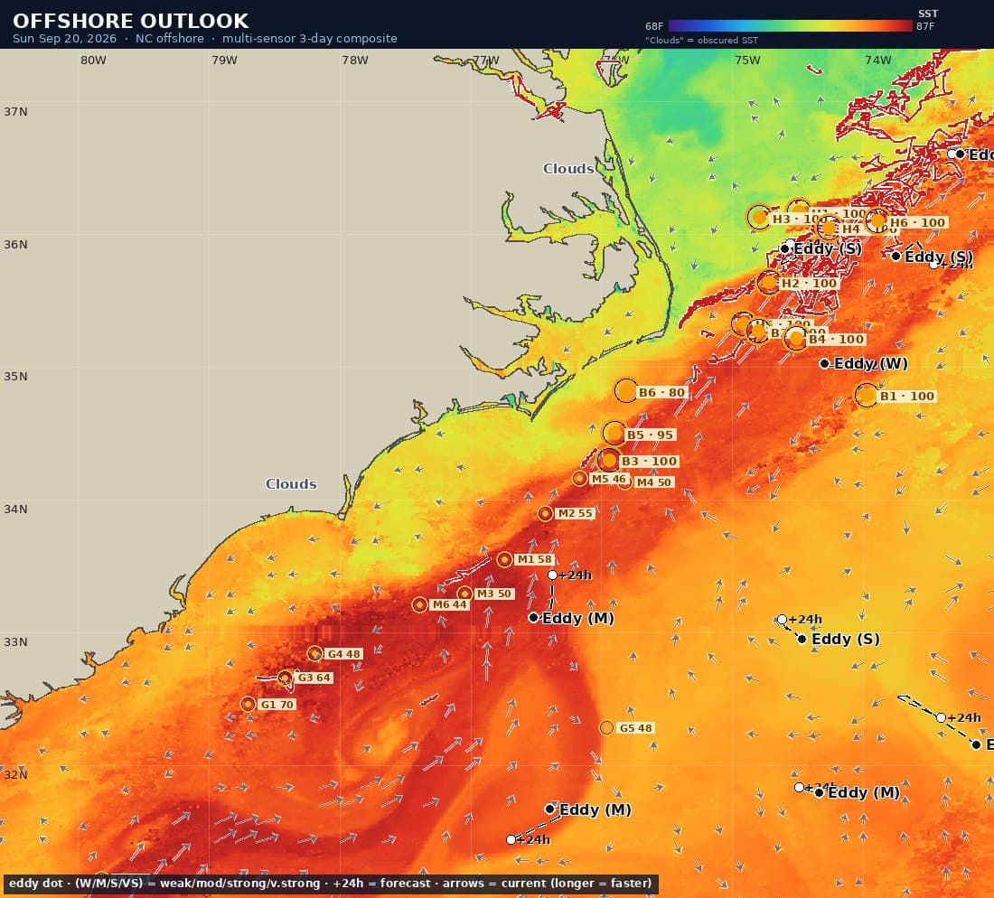
- A briefing chart of sea-surface temperature with the day’s hot spots, eddies, temperature breaks and surface currents drawn on it.
- Hot spots carry an ID (H1, B2, M3…) that matches the chart, the write-up and the email, so you can go from the map to the discussion to the helm without hunting.
- Each spot has coordinates, water temperature, water color, depth in fathoms, what is driving it, and the species most likely to be on it this time of year.
- The water-mass picture: how much of the grounds is blue Gulf Stream water, blended water, or green shelf water.
- Named eddies with their strength and where they are forecast to move over the next three days.
- A LORAN-C chart of the same briefing, with TD lines for both chains anglers ran on this coast, for crews whose numbers are still in TDs.
- Per-inlet briefings for ten inlets from Oregon Inlet to Savannah, each zoomed to the water that inlet fishes, with range and bearing from the inlet to every spot. Choose a home inlet and the morning email carries your water; the coast-wide overview is always a choice.
- An offshore forecast block for every inlet zone from Oregon Inlet to Savannah: NOAA wind and seas with Small Craft Advisory flags, tides, solunar feeding periods and sunrise/sunset.
- Delivered by email before dawn, with the full briefing attached as a PDF. One-click unsubscribe.
- Honest about coverage: it tells you how much of the chart came from today’s satellite passes and marks the areas cloud kept hidden.
In testing — not yet available to everyone
- A chartplotter file of the day’s spots, breaks and temperature lines for Garmin® units.
Interactive Ocean Map
Satellite ocean data on a chart you can plan on.
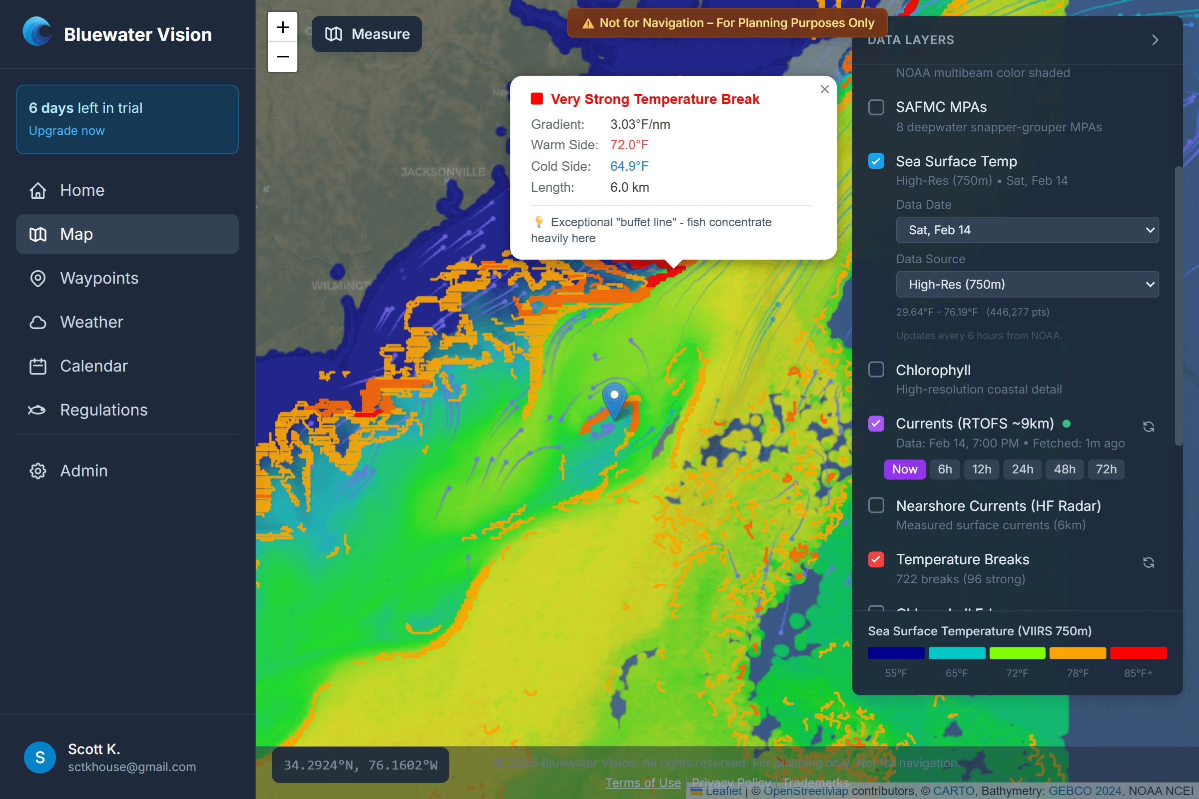
The map puts sea-surface temperature, water color, currents, salinity and bottom structure on one chart, refreshed through the day. Tap any patch of water for its temperature, color, current, depth and marine forecast. It answers: what does the water actually look like out there right now?
What you get
- Sea-surface temperature three ways: a 3-day composite that fills in cloud gaps with the most recent clear look at each patch of water, a single night’s high-resolution pass, and a cloud-free gap-filled view.
- The composite tells you how fresh each reading is, so a two-day-old fill is never mistaken for last night’s pass.
- Water color (chlorophyll) to find the blue-to-green change where bait and predators gather.
- Temperature breaks, color edges and salinity fronts traced on the map automatically, graded by strength, and kept clear of sounds, bays and the beach.
- Breaks that have held in place for several days read bolder - a front that has been there all week is worth more than one that appeared overnight.
- Ocean currents now and forecast out to three days, plus measured nearshore currents where coastal radar covers.
- Named, tracked eddies with a trail of where they have been and a forecast of where they are going.
- The Gulf Stream’s north wall, redrawn daily.
- Bottom detail: depth shading, contours, high-resolution survey relief, NOAA nautical charts and the deepwater marine protected areas.
- A measuring tool for range and bearing between any two points.
Hot Spots
Where the conditions stack up, scored and explained.
Hot spots mark the places where several good signs coincide - a temperature break, a color change, the edge of an eddy, the right depth, the right season. Each one is scored and comes with a plain-English reason, so you know why it is on the chart and can judge it for yourself.
What you get
- Every spot shows what earned it: for example, on a strong temperature break, a mile off an eddy’s edge, near the 100-fathom line.
- Two tiers - hot spots where several features converge, and ranked spots where one notable edge is worth the run.
- Spots are chosen for each stretch of coast, so every inlet gets its own rather than one global best.
- Likely species ranked by how well the spot’s temperature, water color, depth and season fit each fish.
- Shown on the map, in the Outlook and in the daily email with the same ID.
Marine Weather
National Weather Service forecasts for the water you run.
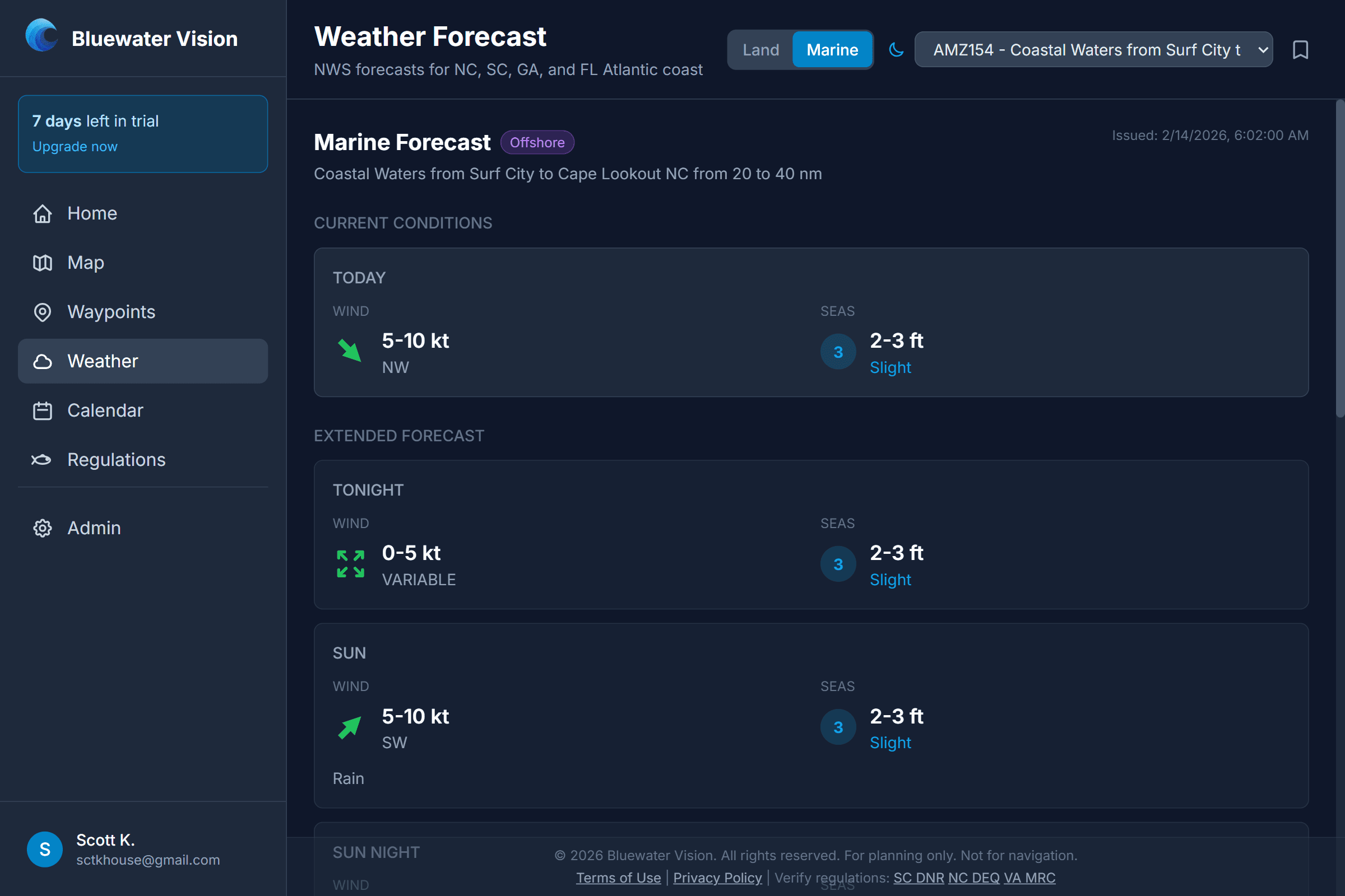
Point forecasts and marine zone forecasts straight from the National Weather Service, from North Carolina to Florida. It answers: can we get out there, and what will it be like when we do?
What you get
- Point forecasts with current conditions, an hourly breakdown and a 7-day outlook for preset ports or your own saved locations.
- Marine zone forecasts by distance from shore - coastal (0-20 nm), offshore (20-60 nm) and sounds - with wind, seas and weather.
- Active alerts, including Small Craft Advisories, shown with the forecast.
- Tap the map anywhere offshore to get the forecast for that water.
Waypoints & Chartplotter Export
Your numbers, organized, and on your plotter.
Save and organize your fishing spots, import the ones already on your electronics, and send them back out to your chartplotter. Your numbers stay private unless you choose to share them.
What you get
- Unlimited waypoints with name, notes, depth, target species, best seasons and type (reef, wreck, ledge, hump, drop-off and more).
- Save a waypoint straight from the map.
- Import GPX and USR files, and Garmin® chartplotter data, with names and notes preserved.
- Export as GPX or USR for Garmin®, Simrad®, Lowrance® and Raymarine® units.
- Color-coded folders for trips, areas or species.
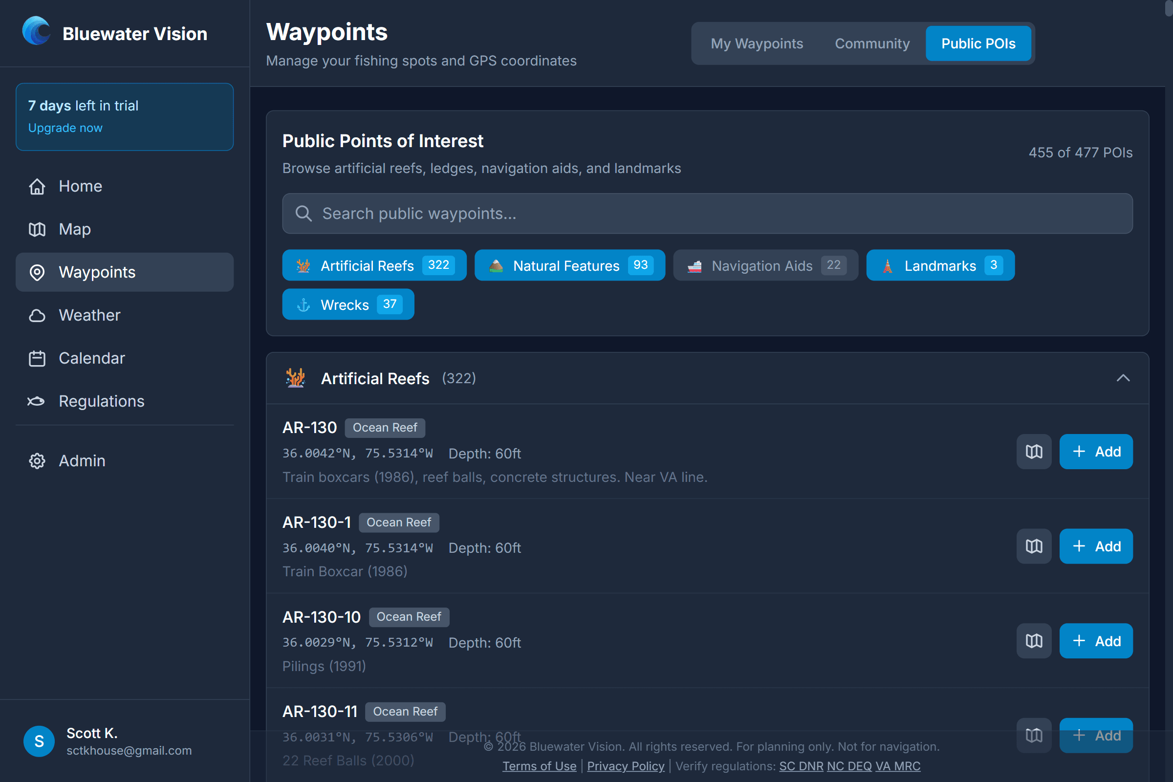
- A built-in library of public points of interest: artificial reefs, wrecks, natural ledges and navigation aids.
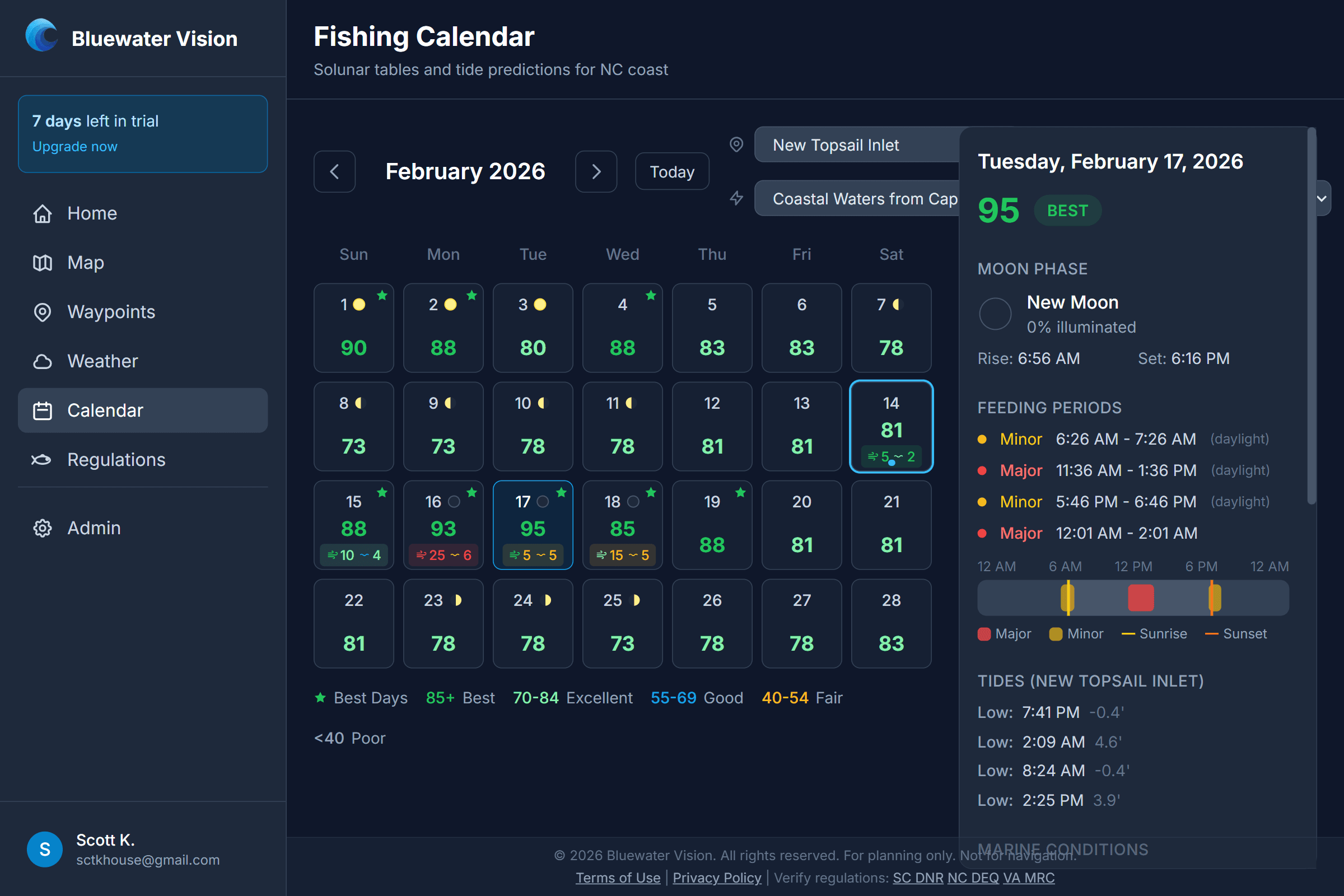
Fishing Calendar
Solunar times, tides and the forecast, day by day.
A calendar that rates every day for fishing and lays out its feeding periods and tides next to the marine forecast. It answers: which day this week, and what time should we be on the spot?
What you get
- A 0-100 rating for each day, color-coded from poor to best.
- Major and minor solunar feeding periods, with moon phase and illumination.
- High and low tides for stations from the northern Outer Banks to Charleston.
- The marine zone forecast for the day alongside, so solunar, tide and weather are on one screen.
- All times shown in Eastern time.
Fishing Regulations
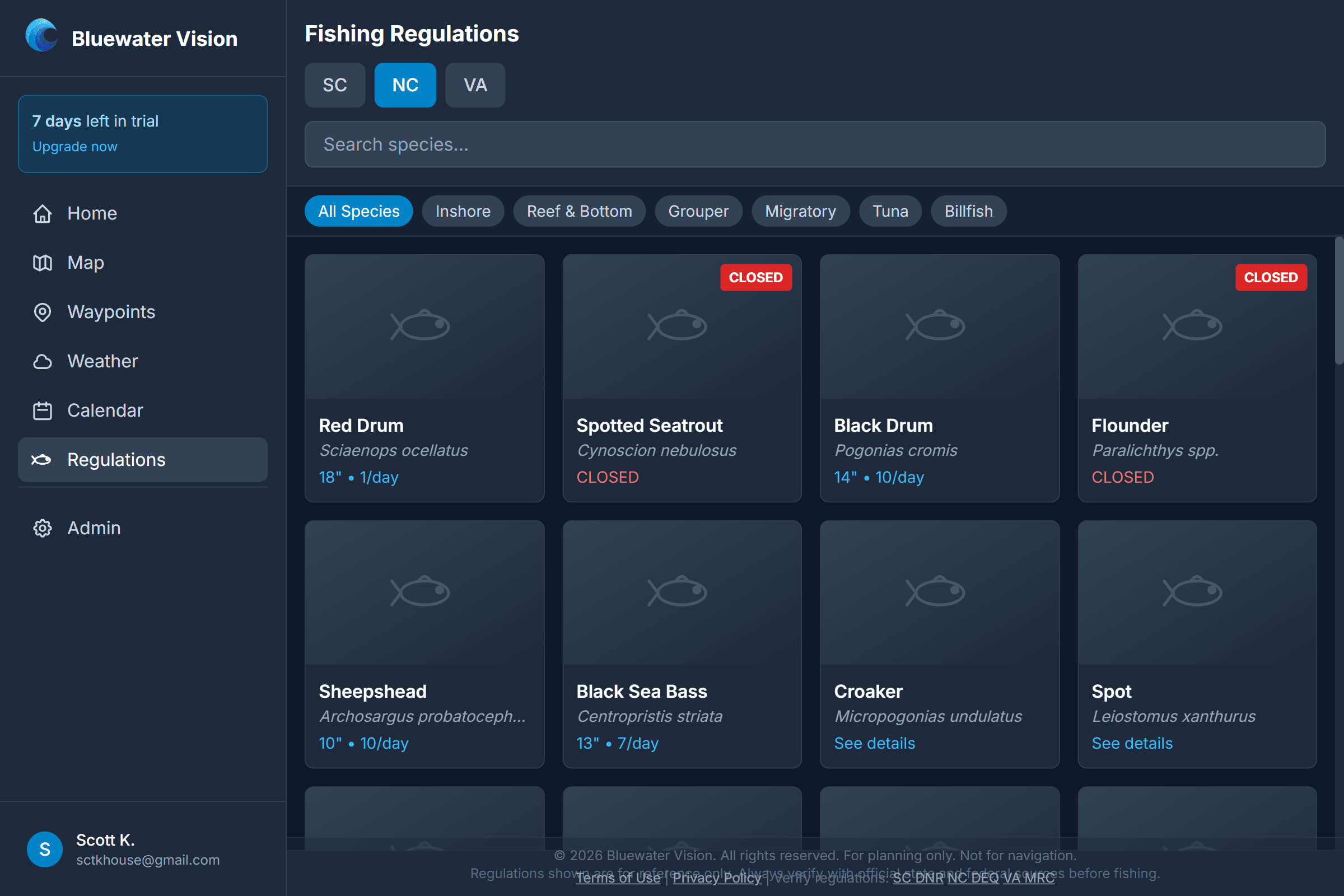
Season, size and bag limits before you keep a fish.
A quick reference for recreational saltwater regulations in South Carolina, North Carolina, Virginia and federal waters. It answers: is it open, how big, and how many?
What you get
- More than 40 species, searchable by name and filterable by state and category.
- Minimum and maximum size, daily bag limit, open and closed seasons, and special notes.
- State and federal rules shown separately where they differ.
- Closed fisheries flagged clearly.
- Every entry links to its official source and shows when it was last checked.
Fishing Groups
Share spots with your crew and nobody else.
Private groups for sharing waypoints with the people you fish with. It answers the old problem of getting numbers to your crew without putting them on the internet.
What you get
- Create a group and invite members.
- Share chosen waypoints with the group - only members can see them.
- A separate, opt-in community list where anglers can publish spots, rate them and comment.
Pricing
$5.99 a month or $71.89 a year, with the first month at $0.99. Every new account starts with a 30-day free trial and no credit card is required. A no-account demo of the map is open to anyone.
Questions & answers
- What is Bluewater Vision?
- Bluewater Vision is a web app for offshore anglers. It turns satellite sea-surface temperature, water color, ocean currents and marine weather into a daily briefing that points to where the water is setting up - temperature breaks, color changes, eddies and the Gulf Stream - so you can decide where to run before you leave the dock. It works in any browser on a phone, tablet or computer, and can be installed to a home screen.
- What area does Bluewater Vision cover?
- Coverage runs from the Georgia-South Carolina line to the mouth of the Chesapeake Bay and about 250 miles offshore: the South Carolina and North Carolina coasts, including Charleston, Georgetown, Cape Fear, Morehead City, Hatteras and Oregon Inlet, and the Gulf Stream beyond them.
- How much does Bluewater Vision cost?
- $5.99 a month or $71.89 a year, with the first month at $0.99. Every new account starts with a 30-day free trial and no credit card is required. A no-account demo of the map is open to anyone.
- Do I need to install an app?
- No. Bluewater Vision runs in a web browser on a phone, tablet or computer. You can add it to your home screen so it opens like an app.
- Who is Bluewater Vision for?
- Recreational and charter offshore anglers running out of South Carolina and North Carolina inlets for tuna, mahi, wahoo, marlin, sailfish and king mackerel - anyone who currently reads satellite temperature charts themselves or pays for a fishing forecast.
- What is the Offshore Outlook?
- A daily, automatically generated offshore fishing briefing for the Carolina coast. It summarizes sea-surface temperature, water color, currents, eddies and the Gulf Stream, and highlights specific numbered spots where several favorable conditions line up, each with coordinates and a short explanation.
- When does the Outlook come out?
- It is rebuilt several times a day as new satellite data arrives, and the email goes out before dawn Eastern time so it is waiting when you are planning the morning run.
- Does the Outlook guarantee fish?
- No. It shows where ocean conditions favor pelagic fish, not where fish are. Some days it marks few or no spots - that means nothing stood out, and we would rather say so than invent one.
- Where does the sea-surface temperature data come from?
- From NOAA and NASA weather and ocean satellites, processed several times a day. High-resolution passes show fine detail but are blocked by cloud, so the map also offers a multi-day composite and a gap-filled view.
- Can I try the map without an account?
- Yes. A demo of the map is open to anyone, with no account and no card, centered on the Wrightsville Beach area.
- How is a fishing hot spot chosen?
- By looking for places where several favorable ocean features coincide - temperature breaks, color changes, eddy edges, bottom structure and season - and scoring how strongly they line up. Each spot states which features put it there.
- Which chartplotters does Bluewater Vision work with?
- Waypoints export as standard GPX, which Garmin, Simrad and Raymarine units read from an SD card. It also imports GPX and USR files and Garmin chartplotter data.
- Can other people see my waypoints?
- No. Your waypoints are private. You can choose to share specific spots with a private group, or contribute one to the community list, but nothing is shared unless you do it.
- Are the fishing regulations official?
- No. They are a convenience reference, reviewed regularly against state agency and NOAA Fisheries sources, but they may not reflect a same-day emergency closure. Always confirm with your state wildlife agency and NOAA Fisheries before keeping fish.